|
Boundaries
Resources
Evaluation |
|
The WHEN, the HOW
and the WHERE gives us the basis of design and can be described
thus:
-
TECHNIQUE
is the how of doing
things and is one dimensional
-
STRATEGY
is the when and how and is
two dimensional
-
DESIGN
is the when, the how
and the where and is three
dimensional
The Design
Process approached the design challenge from the perspective of a
client -designer relationship. The process
reviewed the steps from the initial design proposal, through to the
delivery of the completed design, and placed heavy emphasis on the
participation of the client (community) in all stages of the process.
Design
Sequences are
acronymic-lists of stages in a design challenge that focus the designer on
taking a systematic approach to the design. The two most
often used in permaculture design have distinctly different origins -
BREDIM comes from industrial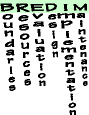 engineering, and SADI comes from landscape architecture. The
individual words of BREDIM can be seen to right. SADI stands for
Survey, Analysis, Design and
Implementation. Both sequences are similar in that a site survey (SADI)
would establish Boundaries and onsite Resources (BREDIM); Analysis (SADI)
is similar to Evaluation (BREDIM); Implementation is common to both; and
many people add in maintenance to make the sequence from landscape
architecture more complete (i.e. SADI(M)).
engineering, and SADI comes from landscape architecture. The
individual words of BREDIM can be seen to right. SADI stands for
Survey, Analysis, Design and
Implementation. Both sequences are similar in that a site survey (SADI)
would establish Boundaries and onsite Resources (BREDIM); Analysis (SADI)
is similar to Evaluation (BREDIM); Implementation is common to both; and
many people add in maintenance to make the sequence from landscape
architecture more complete (i.e. SADI(M)).
We shall look in more
detail at the first three stages in BREDIM because it is explicit about
two important features of a site survey. Neither sequence explicitly
encourages the involvement of the client in the design process, or
involves a stage where the design brief is developed with the client. The
engineering and landscape architect professions undoubtedly have their own
methods for this, and we have seen some methods that permaculture
designer’s use such as PASE, questionnaires, checklists, PMI, and the
presentation of the conceptual design for feedback. We will see more of
these methods (i.e. overleaf) but before we do, we will explore the
usefulness of the design sequence.
-top
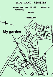 BOUNDARIES –
make a map
It is likely that
there is a published map somewhere that will provide you
with a scale drawing of the basic shape of the site of your
design challenge. Local central libraries keep a range of different scale
maps from which you are allowed to make photocopies for home use (a scale
of 1:1250 will show individual houses in urban areas: 1:2500 has field
sizes/areas on it; 1:10,000 is the largest scale that covers the whole of
the UK; 1:25,000 is available in shops and shows field boundaries and
contour lines every 5m – the Pathfinder series). You may also have
Land Registry documents that deal with ownership and
in which you should find a map that sets out property boundaries. I used
this source for a plan of my own garden (see the Land Registry map, 1:1250
scale and below). BOUNDARIES –
make a map
It is likely that
there is a published map somewhere that will provide you
with a scale drawing of the basic shape of the site of your
design challenge. Local central libraries keep a range of different scale
maps from which you are allowed to make photocopies for home use (a scale
of 1:1250 will show individual houses in urban areas: 1:2500 has field
sizes/areas on it; 1:10,000 is the largest scale that covers the whole of
the UK; 1:25,000 is available in shops and shows field boundaries and
contour lines every 5m – the Pathfinder series). You may also have
Land Registry documents that deal with ownership and
in which you should find a map that sets out property boundaries. I used
this source for a plan of my own garden (see the Land Registry map, 1:1250
scale and below).
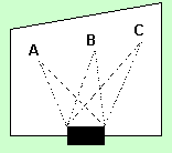 It is rare to have a clean
sheet to work with on most sites. If there are already permanent features
on the site then you will need to be able to transfer those accurately to
a basic plan of your site – this is the start of base mapping.
The simplest way to do this to have two fixed points on your
site from which you can start to take measurements. The corners
of a house would do, or you may have to drive in two posts.
The aim is to measure the distance to any of the
permanent objects on your site from BOTH
of those fixed points (i.e. to A, B and C from the two
corners or posts). If you then locate and draw the house or posts on your
plan, you can begin to triangulate the location of your
fixed objects. Pick a scale that makes it easy (i.e. 1cm on
your map could be one metre measured on the ground i.e. a scale of 1:100)
and use a pair of compasses to draw an arc
from each fixed point on your plan – the two arcs will overlap
on the plan where your feature is. Do this for all the features and for
anything significant on your boundaries. On larger sites, where long
measurements are impractical, measure from feature to feature across the
site, ensuring that there are at least two measurements to each feature,
plus some cross measurements to fixed points on boundaries to tie-in
features. It is rare to have a clean
sheet to work with on most sites. If there are already permanent features
on the site then you will need to be able to transfer those accurately to
a basic plan of your site – this is the start of base mapping.
The simplest way to do this to have two fixed points on your
site from which you can start to take measurements. The corners
of a house would do, or you may have to drive in two posts.
The aim is to measure the distance to any of the
permanent objects on your site from BOTH
of those fixed points (i.e. to A, B and C from the two
corners or posts). If you then locate and draw the house or posts on your
plan, you can begin to triangulate the location of your
fixed objects. Pick a scale that makes it easy (i.e. 1cm on
your map could be one metre measured on the ground i.e. a scale of 1:100)
and use a pair of compasses to draw an arc
from each fixed point on your plan – the two arcs will overlap
on the plan where your feature is. Do this for all the features and for
anything significant on your boundaries. On larger sites, where long
measurements are impractical, measure from feature to feature across the
site, ensuring that there are at least two measurements to each feature,
plus some cross measurements to fixed points on boundaries to tie-in
features.
-top
RESOURCES
When you have completed your basic map,
you should make copies of it and start to use them to fill in more detail about the location, and thus
produce the base map (could be a series of themed plans).
You will have all the boundaries and what they are made of,
and who takes responsibility. You also need points of access
such as roads, gates and paths; areas of frequent people use
such as benches, banks, patios and gazebos; and the
desire lines through the site where people tend naturally to
walk, even if there isn’t a path there. There will also be potential
resources you can identify such as water collection from roofs and other
surfaces, waste products looking for a use, natural resources such rocks,
stones and wood. Identify soil types, different habitats, and information
on water drainage to find free-draining or
boggy areas (see the checklist). In a people orientated design, you will
need to do a skills audit alongside a listing of the physical material and
equipment. Above all, you will be using all your skills and senses
of observation.
start to use them to fill in more detail about the location, and thus
produce the base map (could be a series of themed plans).
You will have all the boundaries and what they are made of,
and who takes responsibility. You also need points of access
such as roads, gates and paths; areas of frequent people use
such as benches, banks, patios and gazebos; and the
desire lines through the site where people tend naturally to
walk, even if there isn’t a path there. There will also be potential
resources you can identify such as water collection from roofs and other
surfaces, waste products looking for a use, natural resources such rocks,
stones and wood. Identify soil types, different habitats, and information
on water drainage to find free-draining or
boggy areas (see the checklist). In a people orientated design, you will
need to do a skills audit alongside a listing of the physical material and
equipment. Above all, you will be using all your skills and senses
of observation.
EVALUATION
This where you start to compare your base map information
with the needs identified by PASE, questionnaires or other events. Use a
simplified version of the base map to start to experiment
with the developments you want to bring about. Get
feedback from the site by also experimenting in real scale
– use lengths of rope or hose pipe and various
canes or sticks to map out ideas. Flat plans (2D) sometimes can’t get you
inspired, so make simple 3D models so that you can do your evaluation by
seeing the solutions. Be flexible,
think about the design principles and make your mistakes on paper first.
When you are satisfied with your evaluation of the desired elements, their
relationships if any, and the use of resources
on site, then turn it into a conceptual design - whether it is a bubble
design, functional diagram, concept plan, or a design development sketch –
and present it for feedback to the client.
Mark Fisher -
Permaculture Design course handout notes
www.self-willed-land.org.uk
mark.fisher@self-willed-land.org.uk
-top |