|
|
The natural vegetation of England |
|
|
|
A couple of months ago, I started asking the question about where we should reintroduce lynx (1). Since lynx are an ambush hunter of wild deer, and thus commonly associated in their natural range with wooded landscapes (2) I went through the results of some mapping using the deciduous woodland inventory of Britain to identify areas of higher woodland cover. Our mapping picked out a large area of SE England, and for which I had no easy answer as to why so much woodland cover is concentrated there (1). Ian contacted me, excited by the thought of lynx reintroduction in his home area of leafy Surrey, as he had always assumed that it would elsewhere, in remote upland areas. Ian’s blog Frequently Found Growing on Disturbed Ground (3) has a rich vein of exposition on human ecology, and he ventured the thought that there might be a correlation between relative affluence and percentage tree cover, the more affluent having the means to make choices about the landscape characteristics surrounding them, given that woodland is likely less or non-productive in terms of income. I had considered this, as well as considering land ownership, alighting on the fact that about two-thirds of the woodlands of the SE region are in private ownership, with the remainder being owned or managed by the Forestry Commission, local authorities, other public sector owners and the voluntary sector (4). Thus if the land was easily exploitable for any other more profitable use, then that woodland would be long gone. The argument that you will see most, though, is that the historic value of the regions woodlands as providers of products, from fuelling iron-making in Roman and Tudor times, to construction timber, leather tanning and brushwood for fuel in more recent centuries, helped to ensure their survival. This usefulness to the people within the region and in neighbouring London is also used to explain why nearly half of all the woods in the region are ancient, having had continuous tree cover since 1600, and that this is 40% of England’s overall ancient woodland area. However, the argument based on woodland products becomes weaker into modern times when they were superseded by such as coal and bricks. Woodland thrives where land is poor for agriculture The real reason for the wooded character of the SE is given in a report on its cultural heritage (5). The varied geology and land form gives rise to poor soils in many areas, the clay soils difficult to work, waterlogged in winter and experiencing drought conditions in summer, or in contrast are very sandy with porous, unstructured soils. These properties do not lend the soils to continuous cultivation, but while the soils were no good for intensive use, they could sustain woodland, and thus were mostly spared from extensive wholesale clearance. The preponderance of clay soils in the SE region, either slowly permeable, with impeded drainage or wet, can be seen in a soilscape map of England (6). This correlates with the Agricultural Land Classification mapping of the region (7) the land graded according to the degree to which physical or chemical properties impose long-term limitations on agricultural use, such as climate, site factors (gradient, flood risk) and soil characteristics (8). There is very little Grade 1 and 2 land in the SE region, the most productive and flexible land, and there is more Grade 4 amongst the Grade 3 when compared to other lowland areas. The Agricultural Land Classification map also shows a substantial number of areas of Non-agricultural land, that being land that according to the criteria for grading currently has other uses, such as private parkland, golf courses, public open spaces and sports fields (8). There is perhaps another use, since in the W of the region it correlates with the predominance of sandy soils. Ironically, it is these sandy soils where there were large areas of heathland that have contributed most to the rise in secondary woodland in the region (after 1600) especially in the Low Weald, either through plantations of conifers or natural regeneration after grazing and active cutting ceased (see Fig 3 in (5)). The distribution of this secondary woodland is uncannily similar to the districts in the region that are at the top end of the range in the generally higher woodland cover of the region, having more than three times the England average (the report used 8% as the average, and also shows districts with twice and three times that amount – see Fig 5 (4)). It is of course this secondary woodland on heathland that is constantly under attack from the conservation industry, especially in Surrey and Hampshire (9). Forest turned into field
It has always been the case, since the
Neolithic settlers brought farming to our land around 6000 years ago, that
areas of woodland were systematically cleared for agriculture. The
settlers at first brought with them polished stone axe heads set on a
wooden haft to ring and fell trees, some made from jadeite quarried in
northern Italy, before using flint axes known to have been mined from
Cissbury in Sussex and Grimes Graves in Norfolk, and the polished
fine-grained greenstone from Great Langdale in the Lake District (10).
That there is a binary opposition between field and wood is
embedded in the origins of the word field. John Horne Tooke (1736 –1812)
in the second part of his philological treatise The
Diversions of Purley published in 1805, defined the origins of the
word field. He wrote that it is (11): Tooke quoted passages from two English writers of the late middle ages - John Gower (1330 – 1408) and Geoffrey Chaucer (1343 –1400) – to illustrate his point, this sentence from Gower’s Confessio amantis (The Lover's Confession, 1386-1390) putting it into context “In woode, in felde, or in citee”. Tooke also showed that there was a correspondence in a number of European languages between the verb to fell and the word for field, such as “vellen” and “veld” in Dutch, “fälla” and “fält” in Swedish, and “faldt” and “felt” in Danish.
In the preface to his own study of words
published in 1853, Richard Chenevix Trench (1807-1886) an Anglican bishop
and poet, notes the shortcomings in occasional details of Tooke’s
etymology in Diversions, “or in matters more serious still”, but
allows the contribution a first acquaintance with Tooke’s work will have
made to “many a student's intellectual life” (12).
They did, however, agree on the etymology of the word field: Tooke had also noted a correspondence between the words fell and field in the German language, with “fellen” (“fällen”) and “feld”. At the same time that Trench was giving his etymological derivation of field, German writer and journalist Willem Riehl (1823–1897) was laying out his reasons why the wooded landscapes of Germany were essential to the national character of its people. In 1848, revolution was sweeping across Europe, with Riehl reporting on the large popular assemblies and mass demonstrations that occurred in the south and the west of Germany (13). When the demands for a united Germany and greater freedoms came to nothing, Riehl became disenchanted with the factional splits and with the process of political participation. Instead, he set out to understand how the German landscape contributed to national character through a systematic cultural study, the first of its kind, and for which he devised questionnaires about people’s habits and beliefs, interviewing people from all walks of life. The genuineness to which living nature alone gives meaning He learned from his wanderings over the country that everyday folk had a definite historical and natural origin, allowing him to divide Germany into forest, field and coastal communities, the differences of climate, soil, topography, leading to different customs, use of the land, food, clothing, houses and even beliefs. His field research began to be published in the four volumes that make up The Natural History of the People as the basis of a German Social Policy. The first volume – Land and People – published in 1854, was organized around a series of oppositions between those aspects of the land shaped by the engine of the market and those that had escaped its force, these oppositions encompassing the nexus between the wood, field and city (14). Riehl argued that the trends of urbanization and capitalism would destroy the social, political and economic strength of the German people. He rejected all artificiality and materialism, defining modernity as a nature contrived by man and thus devoid of that genuineness to which living nature alone gives meaning. His was a natural aversion to the extreme measures of a civilization that would absorb every form of wild nature.
It was in the woodland villages and its
woodland folk that Riehl saw the most natural basis for social groups,
where human development existed within the limits imposed by nature,
rather than nature being bent to human use. Thus a “village without
woods is like a city without historical buildings, without monuments,
without art-collections, without theatres and music—in short, without
emotional or artistic stimulation”. It was the difference between
field and forest – Feld und Wald - the “tame” and the
“wild” cultivation of Germany’s soil. Riehl dreaded the prospect of a
world where all forest land had been turned into cultivated land: Riehl noted that Germany still had “real forest… a whole group of regular forest lands” and where “in contrast to field, meadow, and garden, everyone has a certain right to the forest, even if it consists merely in being able to run about in it at pleasure”. He also noted that the forest alone allows us to “enjoy the dream of a personal freedom undisturbed” where “at least one can ramble about as one will”. In contrast to these “fragments of ancient Germanic sylvan liberty”, they no longer existed in neighboring lands that had greater political freedom, where “annoying fences very soon put an end to an unfettered desire to roam at will". He asked “What good do the Englishmen get out of their free laws, since they have nothing but parks inclosed by chains, since they have scarcely any free forest left?” Our history of deforestation meant that “the English no longer even know how to appreciate the free forest…..England, on the contrary, has practically no really free forest left—no forest which has any social significance. This, of necessity, occasions at the very outset a number of the clearest distinctions between German and English nationality”
Riehl regarded those countries that held on
to their forest not only had a present, but also a future, thus in
Russia's “impenetrable forests…is hidden the future of the great Slav
Empire”, whereas our lack of “genuine forest” meant that
England was “confronted by an already partially extinct national life”.
As with Trench, he was aware that America retained primeval forests. He
considered that the permeation of American society with materialism risked
it becoming degenerate if it were not for that primeval forest, out from
which its national character could be reinvigorated. He likened that
“wilderness” to an immense reserve of unspent capital, which while
America could risk some of its dividends, it would be foolish to consume
the capital itself. Thus he argued that Germany should preserve its
forests because they were the “pulse of the nation's life", “the
richness of peculiar national characteristics in which lies concealed the
tenacious rejuvenating power of our nation”. He believed that the
preservation of ancient popular customs did not depend so much on the
contrast between the mountains and lowlands, but on the contrast between
the woodland and the field. Riehl ended his chapter on forest and field
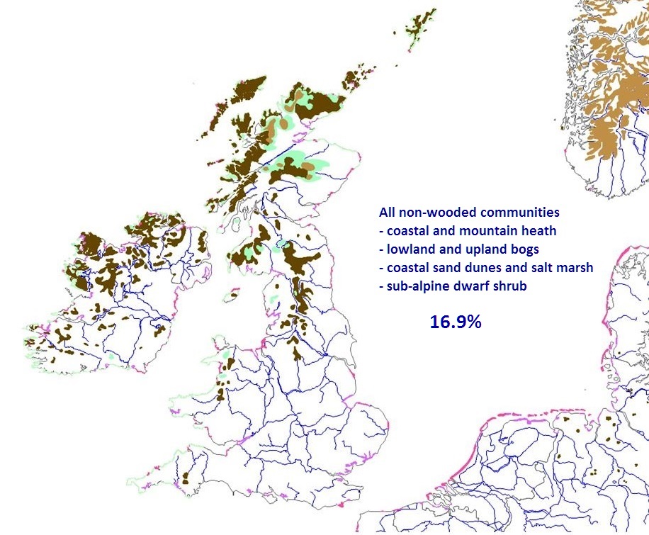
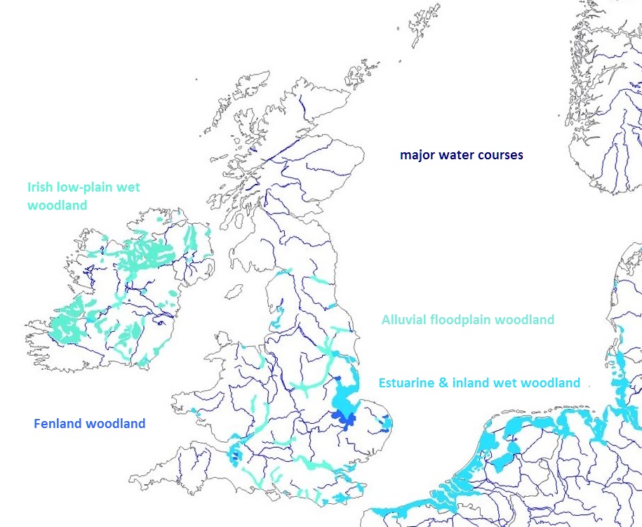
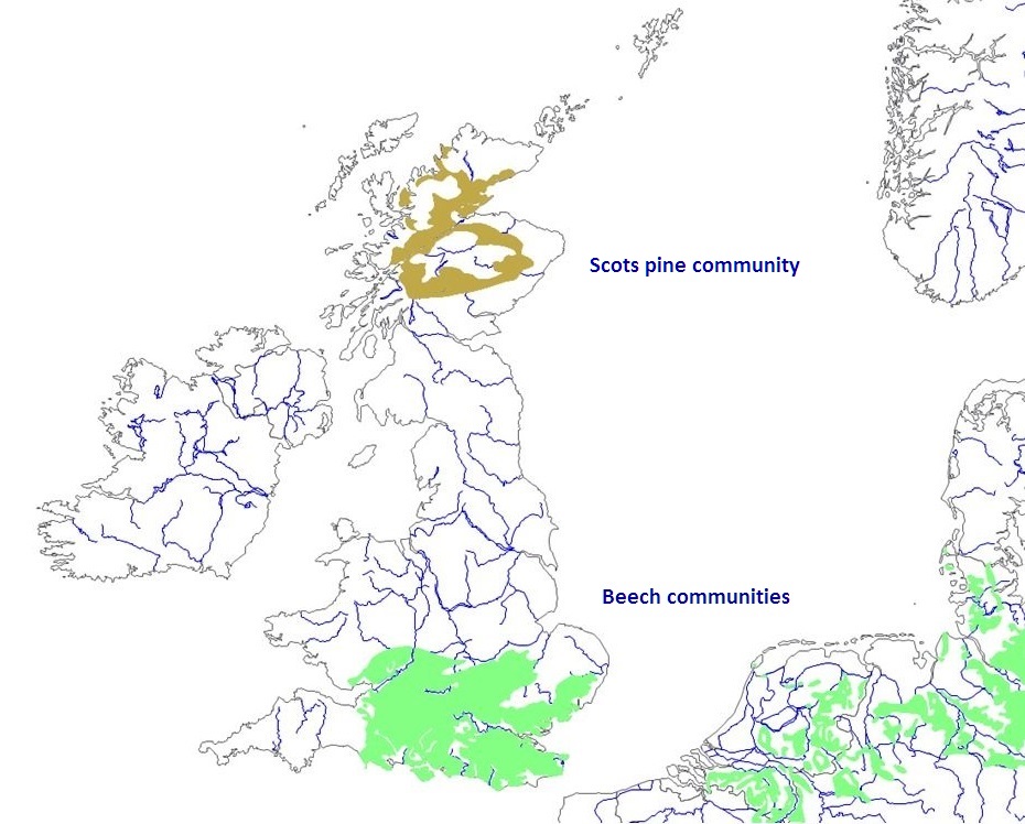
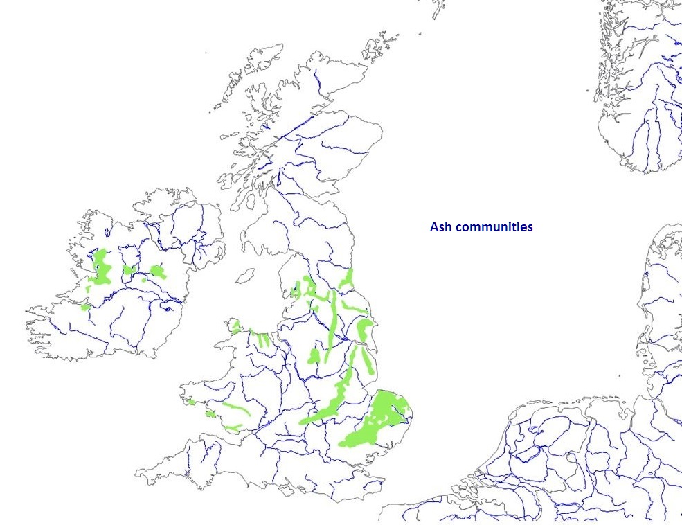
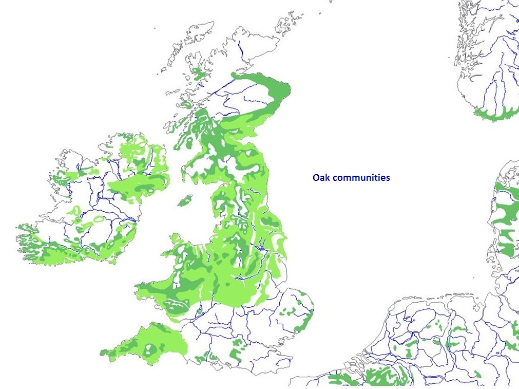
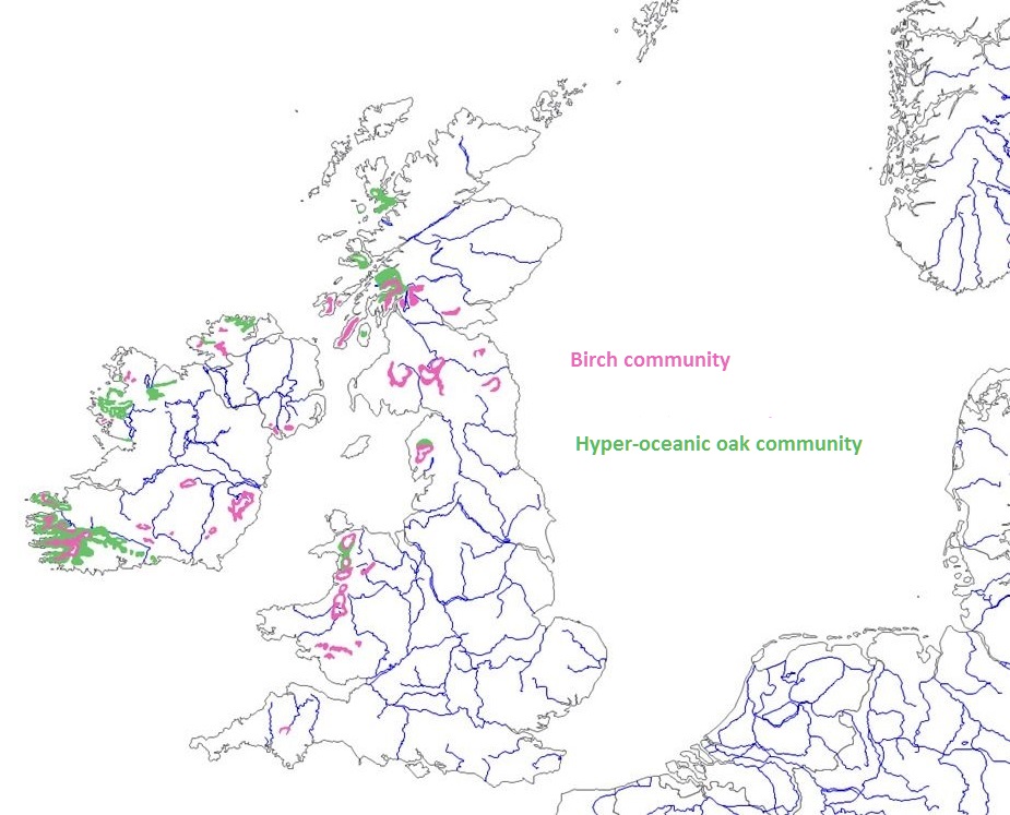
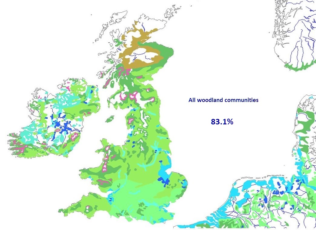
with what has perhaps become his mostly wide quoted passage: The geographical and social relationships of plants Riehl also took swipes at France and Italy, but was he right about England? Before answering that, it’s worth reviewing how the understanding of landscape vegetation developed over the nineteenth century. Alexander Humboldt (1769-1859) a German geographer and naturalist, was a pioneer in phyto-geography (plant geography). He recognized during an expedition to Latin America that there was a zonation of plant life in mountains related to elevation, the spatial coincidence of plant formations linked to the climatic conditions in which they were growing, these observations being published in Essai sur la géographie des plantes in 1805 (15). Humboldt’s observations inspired others to explore phyto-geography, including Danish botanist Joakim Schouw (1789-1852) who while travelling to Norway in 1812 noticed the conspicuous zonal division of the mountain vegetation and the altitudinal distribution of plant species. In 1822, he published Grundtræk til en almindelig Plantegeographie (Outline of a general plant geography)(16). Alphonse Pyramus de Candolle (1806-1893) was also inspired by Humboldt, his book Géographie botanique raisonnée on botanical geography from 1855 discussed the physical conditions experienced by plants of temperature and light, altitudinal and latitudinal effects, before looking at more local determinants of plant distribution, such as soil mineralogy, but he also considered the action of animals in excluding or promoting the development of species (17). Thus goats or cows could prevent forests or herbaceous plants from growing, and their excrement altered the presence or frequency of grassland species. The action of insects, birds, and small animals could also have effect – “The multiplication of an insect attacking the seeds of a species, that of a greedy rodent of some root or seed-eating bird, can significantly change the vegetation of a district without anyone notice the cause” Yorkshire-born botanical geographer, Hewett Watson (1804-1881) used his own and existing county records for the presence of plant species to devise a system to indicate their distinctive range by assignment in to zones based on altitude, and into provinces based on river drainage (18). These spatial distributions for species were published in four volumes of Cybele Britannica between 1847 and 1859. His later two-volume set of Topographical Botany in 1873-74 gave a comprehensive listing of individual species in county records, but without reference to the altitudinal and latitudinal elements (19). Danish botanist Eugun Warming (1841-1924) collected together his lectures on plant geography at the University of Copenhagen, and published them as a textbook on plant ecology in 1895 (20). The book – Plantesamfund- Grundtræk af den økologiske Plantegeografi (Plant Society - Basics of ecological plant geography) was the first to have the word ecology in its title. The book introduced the concepts of plant communities, and of growth forms, as well as covering the major habitats through ecological classes established on the basis of edaphic and climatic distinctions, including hydrophytic, xerophytic, halophytic, and mesophytic communities. His aim was to explain how nature solved similar problems (drought, flooding, cold, salt, herbivory) in a similar way, despite the plant species being from different families and in different regions of the world. I am particularly fascinated by his discussion of thorns and spines derived from buds and leaves, as an example of structural growth forms, the obvious purpose being as a deterrent to browsing by herbivores, but the evidence was that it is not a universal phenomenon in response to browsing. The study of phyto-geography continued to offer up new concepts. After contact with a wide range of vegetation covers - forest, steppe, wooded steppe, and desert - Polish botanist Józef Paczoski (1864-1942) noted that they formed distinct communities of plants driven by the environment of their location, and so he coined the term phytosociology (fitosocjologia) to define their sociological relationship in a paper from 1896 entitled Zycie gromadne roślinin (Interactions of plant life) (21). While working as a librarian in Dublin, Irish naturalist Robert Praeger (1865-1953) set out walking at weekends in 1896 to complete a detailed geographical analysis of Ireland's plants, based on Watson’s approach of county divisions. He took 40 days a year over five years before he was able to compile his systematic fieldwork and existing county records into the Irish Topographical Botany, published in 1901 (22). Although Praeger introduces the climate and soils of Ireland, discusses the topographical divisions and their vegetation, and gives the typical vegetation based on soil and moisture, he only broadly compares the Irish flora with the distribution of plants in Watson’s provinces, and makes no use of the latter in the county distributions of individual species. The first survey of British plant communities Inspired by Warming's Plantesamfund, Arthur Tansley (1871-1955) set out in 1904 with a committee of fellow plant geographers to systematically survey and map British plant communities, work that had begun in Scotland in the late 1800s. Types of British vegetation was published in 1911, and it offered a different approach to that of Watson, because it was the first account of British vegetation based on the different types of plant associations – the phytosociology of plant communities - existing in the natural and semi-natural vegetation, tracing their relationship to climate and soil (23). The physical characteristics and climate of Britain, its soils, geology and geomorphology, are outlined early in the book, followed by the distribution of plant communities found, with lists of species occurring in them, based on their soil type and broad habitat (clay-loam, sand, marsh, heath, siliceous, calcareous, aquatic, marsh, river valleys and fen, lowland moor, upland moor, and coastal) illustrating some by descriptions of the plant communities in particular locations. It is in the chapter on the distribution of the chief forms of the existing vegetation of the British Isles that we find out that the woodland-plus-plantation cover of England in 1905 was only 5.3%, the low point since woodland recovery after the glaciers receded. Wales and Scotland fared no better with woodland covers of 3.9 and 4.6%. From the percentage cover of all the chief forms, Tansley attempted to gauge the balance between “cultivated land” (implying arable land and permanent grassland) and “natural and semi-natural land”, the latter including “natural grassland”, mountain and heathland. He came up with the proportions of natural and semi-natural land being 15-20% for England, 40% for Wales and 70-75% for Scotland. Comparisons were supplied with other countries, reckoning that France, Holland, Belgium, Germany and the Netherlands at a quarter to a third all had a greater proportion of natural and semi-natural land than England, and with Norway having 96%. The woodland covers were also greater, the Netherlands and Denmark at 7 or 8%, France at 17%, Norway at 22%, and with no surprise that Riehl was right, that at 25%, Germany had five times the woodland cover of England. In considering the origins of the cultivated land, Tansley reflected that all the arable land and permanent grassland had been taken from the original forest area, but much also of the so-called "natural pasture", heathland and moorland that he had regarded as semi-natural, had been derived from forest as well. He noted that a "human community, directly it passes into the first stages of civilisation and increases numerically, is the natural and inevitable enemy of the tree-communities of the countries it inhabits". Thus man had "cut down trees ....to make room for his crops, and to make new pasture" for livestock. In turn, these animals "eat off the tree seedlings, and may thus prevent the rejuvenation of the woods and cause their eventual death". He was aware though of the secondary woodland developed on heaths in the SE, noting that it contributed to the high woodland cover of the region, which at 11.5% was more than double the percentage for England as a whole, and represented more than a quarter of the total woodland area of England. Tansley would later go on to coin the term ecosystem in 1935, which he saw as describing "the whole system" that included the "biotic community" or "organism complex" along with the "whole complex of physical factors", the "inorganic" or abiotic factors, such as climate and soils (24). The true potential natural vegetation is not expressed in agro-ecological habitats I’ve written before of the sleight of hand of the conservation industry in lumping semi-natural habitats in with (near) natural habitats when considering our wild heritage, as Tansley did a century before, so that it could claim for Britain that “around 30% of the land surface is considered to comprise near-natural or semi-natural habitats, which retain a high degree of naturalness and typically support diverse native animal and plant communities” (25). At least there was an admission that there is a wide variation in the distribution and abundance of these habitats across Britain, from 5-15% in many lowland English counties to between 50 and 95% in upland districts of Wales, northern England and Scotland, these being uncannily reminiscent of Tansley’s estimates. I went on to distinguish between semi-natural and near-natural habitats on the basis that while many semi-natural habitats may be dominated by native species, they could not be considered to be near-natural as the true potential natural vegetation was not expressed in these agro-ecological habitats. I ventured the location and extent of remaining areas of this near-natural habitat, based on the inaccessible and least used, and where natural factors were more important than human intervention. While I did not also venture an estimate of the area, it would not be much more than an order of magnitude less than that 30%.
This begs the question about how many of the
plant communities that Tansley described could be considered as natural
when there was so little to observe. Praeger recognised this when he later
wrote about the 5,000 mile journey he made around Ireland during his field
work for Irish Topographical Botany and of his further travels around
Ireland (26). He was disturbed by the planting
of non-native flowers to "beautify the country- side” because it
obscured the present natural distribution of plants, adding to the
inevitable changes that had occurred anyway under the pressure from the
long history of human activity. Here was his reason: There is a contemporary digital mapping system of the Natural Vegetation of Europe, based on surviving remnants of natural and near-natural ecosystems and their correlation with site-specific conditions (climate, soil, temperature, nutrient and water balance) and the distribution of characteristic and differential plant species (27). It brings together plant ranges through phytogeography and phytosociology to display the potential distribution of the dominant natural plant communities under the current climatic and edaphic conditions, and across the different zones of vegetation with regard to longitude, latitude and altitude. The assumption is that these natural plant communities are developed without the effects of direct human intervention and utilisation, nor any interaction with wild animals. The latter has come in for some criticism, that the vegetation on which the mapping is largely based will have experienced a different interaction with wild animals than experienced by the original natural vegetation. This criticism is of course about the absence of action by the lost wild herbivores, in the case of the UK, the mega-herbivores, as well as the large herbivores in the Irish elk, horse and bison, and subsequent extinction of aurochs and extirpation of moose (28). I feel confident in dismissing this criticism since it wilfully overlooks the influence of predators on that herbivory (29). What you have to ask yourself is this - would there have been any places where herbivores would not have felt under threat from predators? Is just reinstatement of herbivores any more valid than having neither in the landscape? Thus in the absence of predators, the default state of natural vegetation can only be assessed by precluding as well an uncontrolled herbivore presence. What I find interesting about this digital mapping system is that it can be used to determine areas of high naturalness by finding locations that deviate the least from the natural potential. Thus one use could be to show the degree of representation of natural ecosystems in our protected areas, the likely outcome confirming the overwhelming presence of semi-natural, agro-ecological habitats (30,31). Perhaps more usefully, it is an opportunity mapping for restoration of missing natural habitats. What the natural vegetation of England could be I have used the mapping system to identity the distribution of the dominant natural plant communities of the UK. There are 35 phytosociological plant communities represented, of these 19 are woodland and which are characterised not just on the dominant tree present but also the species of the shrub and ground layer. The latter is a similar number to that in the National Vegetation Classification system for woodland (W1-18) a system used in the UK that is based on phytosociological associations found here (32). Given that the natural vegetation mapping was based, for cross-comparison purposes, on Europe-wide phytosociological observations, then the level of correspondence revealed between the two gives confidence. Of the remaining non-woodland types, there are lowland and upland bogs, coastal and mountain heath, coastal sand dune and salt marsh, and sub-alpine dwarf shrub (willow, birch, bilberry). All these locations are where I ventured that the climatic or edaphic conditions will not sustain tree growth (see earlier). You may be interested to know that these open, non-wooded habitats cover only 16.9% of the area of potential natural vegetation of the UK. Areas for each of the plant communities are given by the mapping program for the whole of the UK, but it is possible to estimate the area covered just in England, and this will be the focus – you can make your own evaluation for the rest of the UK and Ireland (see the maps in (33)). A very valuable indication is given by the 4% of England that could be covered by alluvial flood plain forest, a vital natural habitat that we are missing and for which there is therefore no community given for it in the woodland NVC (32,34). Thus an alluvial woodland community of oak, ash, alder, wych elm and willow is shown running along stretches of the major rivers, such as the Tyne that runs towards Newcastle; a combination of the Upper Derwent and the Rye below Pickering; a combination of the Lower Derwent, Ouse, Aire, Trent, Dove and Soar that runs from York down to Leicester; the Dee near Chester; the Lugg through Herefordshire; the Severn from Stourport to the Bristol Channel; the Thames from Reading to Grays; and the Stour and Avon, Test, Itchen, Arun, Adur, Uck and Ouse in SE England. In addition, almost 5% of England could be areas of estuarine and low lying inland wet woodland, consisting of mixes of ash, oak, wych elm and some alder, the largest areas unsurprisingly being on the Humber estuary; around the Wash; the Thames estuary; and in the Somerset levels; with the next largest areas being the Norfolk Broads; and in the SE the Pevensey Levels; a combination of the Rother Levels with Romney and Walland Marshes; and the low lying land that stretches diagonally across NE Kent. A third type of wet woodland that could cover around 1% of England is a fen woodland of willow-alder-birch forests, and which is concentrated on low lying land in the Somerset Levels, the northern area of the Lincolnshire Fens, around the Norfolk Broads, and the Fens between Whittlesey and Lakenheath (Great Fen, Wicken Fen). The natural vegetation map clearly shows the restricted natural distribution of woodland communities where beech is the predominant tree. It is confined to the south of England, not reaching much into the West Country or Wales, or much north of Northampton, thus covering an area of about 27%. Three woodland community areas that could develop where beech is the predominant tree are represented (W12, W14, W15) but the larger of these three areas is also interspersed with oak woodland that has some ash woodland (W10). Woodland communities where ash is the pre-dominant tree (W8) could cover about 10% of England and follows the distribution of limestone, including the Carboniferous limestone of the White Peak in Derbyshire, and the Yorkshire Dales running over to the Lake District; the northern section of Jurassic limestone running up to the E coast of Yorkshire; the Permian limestone ribbon running NS to the E of Leeds and upto the mouth of the Tyne River; and the Cretaceous towards the E coast of Yorkshire and Lincolnshire, and running from London to the N Norfolk coast. The rest of the wooded area in England – perhaps 45% of England – is shown as developing with oak as the predominant tree in five different communities, but there is varying amounts of ash in one (W9 with W10) and the others are oak with varying amounts of birch (W11, W16, W17). One of those oak communities, which could develop in northwest Wales, the Lake District and west Scotland, is representative of the Atlantic oakwoods that do exist there, and which share a common hyper-oceanic influence with oak woods in western Ireland, of a luxuriant growth of ferns and mosses (35). A woodland community with birch as the predominant tree, but with also rowan, is shown to develop on hillsides around Dartmoor, and in the Lake District. As you would expect, woodland where the predominant tree is Scot’s pine (W18) is shown to develop in the Scottish Highlands. The conservation industry’s leading ideological bruiser The extent of all woodland of the various types predicted by the natural vegetation mapping equates to 83.1% of the UK. Given what appears to be the relatively greater area of non-wooded landscape in Scotland, the extent in England could be up to 10% higher. This is a prediction that is echoed in the UK Biodiversity Action Plan (UKBAP) and which states that “much of the land surface would have been covered by trees before the first clearances for agriculture took place” (36). However, it is a prediction that would undoubtedly come in for criticism from Tony Whitbread, CEO of Sussex Wildlife Trust and the conservation industry’s leading ideological bruiser. Whitbread was recently quoted in an article about “rewilding” saying that a belief that the natural landscape cover of the UK would have been “wall to wall woodland” is “intellectually lazy” because half of the UK's plants and animals are open landscape and woodland edge species (37). He thus averred that nobody can know what the natural landscape cover would have been, which of course gives him justification to intervene in landscapes in any way he chooses. The argument about species and vegetation cover is the spurious nonsense that comes from those who want to turn our landscapes into open air zoos, full of domesticated large herbivores – usually cows and horses – often grazing in clear-felled areas that have been punched in woodland, a bizarre modern day recreation of the Neolithic (see above and (38,39)). There is of course no linear relationship between numbers of open landscape and woodland edge species and the extent in natural systems of their chosen habitats. Moreover, the notion that livestock can replace or emulate the native browsers and grazers that may have inhabited a region is a nonsense because it results in uneven herbivory on plants. Natural plant communities experience the effects of multiple herbivores, all grazing different plants in the communities, and different parts of plants at different times and seasons, when compared to the single herbivore effects of one or two kinds of domestic animals (40). I would suggest that the “intellectual laziness” resides in those that wilfully overlook the influence of predators on that herbivory, but who also seek to rewrite ecological history in pursuit of their obsession with “crop and crap management” as Neil Fitzmaurice is fond of describing the effect of the cattle grazing on Blacka Moor that is trashing its wetland wildflowers (41). Thus I await Whitbread’s accusation of “intellectual laziness” being directed towards the likes of the Cambrian Wildwood initiative, a speculative and landless project of the Wales Wild Land Foundation to “rewild” part of the Cambrian Mountains through restoring native forest and “resuming grazing” with “Wild horse, wild cattle, bison” (42). There have been no “wild cattle” in Europe since the extinction of the aurochs in 1627 (43). They were anyway unlikely to have grazed the Cambrian mountains, as they had a distinctive distribution in Britain that depended on the flat land of lowland floodplains, and were co-located with moose (44,45). The Foundation’s aim of substituting a “feral breed of cattle such as Heck” is another falsity because a back breeding program to produce an animal looking similar to the aurochs does not mean that it behaves in any way like the original wild animal; that it can exhibit the same habitat selection - phenotype is irrelevant (43). In addition, breeding in wildness from park or fighting cattle is an anthropogenic action that again lacks any means of evaluation and, anyway, de-domestication of livestock through naturalistic grazing – defined as free-living and resource limited, but still enfenced - is wishful thinking when it probably only turns the clock back 1,000 years: the last aurochs in Britain were 3000 years ago (46). It is also “intellectual laziness” to seek introduction of bison and horse, since neither of these species has a legitimate presence here now as a wild species. There is no evidence that the steppe or any other bison returned to Britain after the maximum of the Devensian Glaciation (between 25,000 and 15,000 years ago)(47,48). There was a different type of bison in the rest of Europe during the Holocene, their distribution determined by vegetation patterns and mean winter temperature, with their heartland in Central and Eastern Europe, whereas suitable habitat in Western Europe was scarce (49,50). The wild horse in Britain was also a steppe animal, with no evidence of its presence after about 10,000 years ago (51). Between 7500 and 5750 years ago, the increasing human influence from forest clearance and the introduction of herds of domestic animals changed the vegetation, allowing a re-colonization of continental Europe by wild horses so that their presence is shown in the early to mid-holocene. However, domestication of horses began in the mid-holocene, about 5500 years ago, originating in the western part of the Eurasian steppe, the movement of tamed herds westward supplemented with the continued genetic input from local wild populations, and ultimately ending the wild status of the horse (52). Our woodlands had a richer mammal fauna than today I should acknowledge the Foundation’s aim to restore native woodland, as that is the key issue arising from the natural vegetation mapping. As the UKBAP says, our woodlands had a richer mammal fauna than today, with lynx, bear, wolf, and beaver still present, but that the clearance of perhaps 90% of the UK’s forest cover during the past 5,000 years has been detrimental to many species dependent upon forest conditions, including the loss of many plants and invertebrates, in particular significant extinctions of beetles associated with dead wood (36). What the natural vegetation mapping shows is that through the destruction of woodland cover, we dramatically reduced the potential habitat range for a number of key native species, bringing them further into confrontation with human habitation and utilisation of land. Thus we persecuted them to extinction in our landscapes, such as the mammal fauna listed in the UKBAP above or, like the wildcat, which had its distribution drastically reduced to a presence only in Scotland (53). The range of the pine martin was also reduced, now having its stronghold in Scotland, but with evidence of a presence in some locations in N England and Wales (53,54). Pine martin have been described as a woodland icon because of their preference for woodland that has abundant standing deadwood, a characteristic across Europe of highly natural woodlands (55). Pine martens have a home range that has been estimated at 90-126ha of wooded habitat so that they have a large foraging range (56). Since over 70% of woodland in Britain has an area of less 10ha (see Table 7a (57)) then the bulk of them are much too small to support even a single home range. As the Vincent Trust point out, it is not just the area of woodland and its connectivity with other woodland that is important if pine marten are to be restored to a greater range in England and Wales, but it is also the naturalness of the wood in having good food availability in voles and other prey species, as well as the woodland being mature enough to have cavities in large, standing dead trees in which they have their den sites (55). Thus the Trust assert that reinstatement of large areas of woodland are a priority, and we should start now by strategically expanding woodland where there is clearly evidence that there would be in-migration of extant pine marten. As well as the moral issue, there are good ecological reasons for restoring pine marten because of a reinstatement of natural processes to our woodland through trophic cascades. Being a predator of voles, pine marten will reduce their herbivorous pressure on tree regeneration from eating seeds and seedlings, as well as root cutting and ring barking saplings (58). The grey squirrel is another mammal, albeit non-native, that is destructive of tree regeneration through bark stripping at pole stage, as well as in mature trees, and may be holding back hazel regeneration (57). However, recent studies in Ireland have confirmed that pine marten prey on grey squirrel, less so on red squirrel, but that the crash in the non-native grey squirrel population in the west and midlands of Ireland since the 1980s is correlated with a recovery in the pine marten population and the return of red squirrels to areas where they had been absent for several decades (59,60). From lynx to deer to trees, and from pine marten to vole and grey squirrel to trees, and with the added bonus in the latter trophic cascade of making space for our native red squirrels as the grey squirrels are reduced, the prospect of restoring the natural vegetation and the ecology of our landscapes becomes an ever greater priority. There is a record for the presence of wildcat in the Atlas of Mammals that is close to my home (61). There are only four location records for the whole of England, and they date from the 19th century or earlier, suggesting that they may have been the last holdouts of a species persecuted since Tudor times (53,62). I look out my window at the moor regaining its trees after the removal of millennia of grazing, and I picture the return also of the wildcat. To echo the exhortation of Willem Riehl from 160 years ago, for too long the rights of fields have been advocated here. We must now advocate the rights of forest, even at the expense of the field, so that we can regain our natural heritage, but also so that we, along with wild nature, can “enjoy the dream of a personal freedom undisturbed” Mark Fisher 28 August 2014
(1) Lack of natural control mechanisms - the
missing lynx, Self-willed land June 2014 (2) Breitenmoser, U., Mallon, D.P., von Arx, M. & Breitenmoser-Wursten, C. 2008. Lynx lynx. The IUCN Red List of Threatened Species. Version 2014.2 http://www.iucnredlist.org/details/full/12519/0 (3) Frequently Found Growing On Disturbed Ground http://ondisturbedground.wordpress.com/ (4) Seeing the wood for the trees - A forestry and woodlands framework for South East England http://www.forestry.gov.uk/pdf/stwftt_framework.pdf/$FILE/stwftt_framework.pdf (5) Bannister, N.R. (2007) The cultural heritage of woodlands in the South East. Produced for the South East AONBs Woodlands Programme http://www.forestry.gov.uk/pdf/see-chwse-1.pdf/$FILE/see-chwse-1.pdf (6) Soilscape (England) 2013 http://magic.defra.gov.uk/StaticMaps/Soilscape%20(England).pdf (7) Agricultural Land Classification - Provisional (England) 2013 (8) Agricultural Land Classification of England and Wales: revised guidelines and criteria for grading the quality of agricultural land (MAFF, 1988). http://archive.defra.gov.uk/foodfarm/landmanage/land-use/documents/alc-guidelines-1988.pdf (9) Heathland MADNESS - the juggernaut of nature conservation, Self-willed land www.self-willed-land.org.uk/heath_madness.htm (10) Edmonds, M. (1997) Stone Tools & Society: Working Stone in Neolithic and Bronze Age Britain. Routledge http://books.google.co.uk/books?id=VcMWILjql7EC&lpg=PP1&pg=PP1#v=onepage&q&f=false (11) Tooke, J.H. (1805) ἔπεα πτερόεντα (winged words), or The Diversions of Purley. Part II, pg 44 https://archive.org/details/gpeapterentaord01tookgoog (12) Trench, R.C. (1853) On the Study of Words: Lectures addressed (originally) to the pupils at the diocesan training school, Winchester. Pg. 200 https://archive.org/details/onstudywords01trengoog (13) Gooch, G. P. (1913) History and historians in the nineteenth century. London: Longmans, Green & Co. pg 574-7 https://archive.org/details/a583266900goocuoft (14) Riehl, Wilhelm Heinrich. Die naturgeschichte des volkes als grundlage einer deutschen social-politik. Volume: 1. Land und Leute. Stuttgart : Cotta https://archive.org/details/naturgeschichte01rieh (15) Humboldt, A. and Bonpland, A. (1805) Essai sur la géographie des plantes :accompagné d'un tableau physique des régions équinoxiales, fondé sur des mesures exécutées, depuis le dixième degré de latitude boréale jusqu'au dixième degré de latitude australe, pendant les années 1799, 1800, 1801, 1802 et 1803. Paris: Chez Levrault, Schoell et compagnie https://archive.org/details/essaisurlagogra00bonpgoog (16) Schouw, J.F (1822) Grundtraek til en almindelig plantegeographie. Gyldendalske boghandlings forlag https://archive.org/details/grundtraektilen00schogoog (17) de Candolle, A. (1855) Géographie botanique raisonnée; ou, Exposition des faits principaux et des lois concernant la distribution géographique des plantes de l'époque actuelle. Volume 1. Paris: V. Masson http://books.google.co.uk/books?id=IfETAAAAQAAJ&pg=PR3#v=onepage&q&f=true (18) Watson, H.C. (1847) Cybele Britannica: or British Plants and their geographical relations. Vol. 1. London: Longman & Co https://archive.org/details/cybelebritannica01wats (19) Watson, H.C. (1873) Topographical botany: being local and personal records towards shewing the distribution of British plants traced through the 112 counties and vice-counties of England, Wales, and Scotland. Volume 1. London, Thames Ditton https://archive.org/stream/topographicalbot01wats#page/n0/mode/2up (20) Warming, E. with the assistance of Vahl, M. translated by Groom, P. & Balfour, I.B. (1909) Oecology of plants; an introduction to the study of plant-communities. Oxford: Clarendon Press https://archive.org/details/oecologyofplants00warmiala (21) Paczoski, J. (1896) Zycie gromadne roślin. Wszechświat: Tygodnik popularny, poświęcony naukom przyrodniczym, T. 15, nr 26. Warsawa 1896 (22) Praeger, R.L. (1901) Irish Topographical Botany. Proceedings of the Royal. Irish Academy, 7:1-410 http://www.jstor.org/stable/20488793 (23) Central committee for the survey and study of British vegetation, Tansley, A. G., ed.(1911) Types of British vegetation. Cambridge University Press https://archive.org/details/cu31924001717820 (24) Tansley A.G. (1935) The use and abuse of vegetational concepts and terms. Ecology 16: 284–307 http://karljaspers.org/files/tansley.pdf (25) The revisionism of the conservation industry – expanding the noosphere in Britain, Self-willed land March 2012 http://www.self-willed-land.org.uk/articles/noosphere.htm (26) Praeger, R.L. (1937) The way that I went: an Irishman in Ireland. Dublin: Hodges, Figgis & Co. http://books.google.co.uk/books/about/The_Way_that_I_Went.html?id=HbENAAAAIAAJ&redir_esc=y (27) Bohn, U., Gollub, G., Hettwer, C., Weber, H., Neuhäuslová, Z., Raus, T. and Schlüter, H. (2004) Natural Vegetation of Europe. Version 2.1, in: Federal Agency for Nature Conservation https://www.synbiosys.alterra.nl/eurovegmap/ (28) Chiarucci, A., Araújo, M.B., Decocq, G., Beierkuhnlein, C. & Fernández-Palacios, J.M. (2010) The concept of potential natural vegetation: an epitaph? Journal of Vegetation Science 21: 1172–1178 https://www.bayceer.uni-bayreuth.de/bayceer/en/pub/pub/88701/Chiarucci_concept_of_pnv_J_Veg_Sc.pdf (29) Lack of natural control mechanisms - the missing lynx. Self-willed land June 2014 www.self-willed-land.org.uk/articles/missing_lynx.htm (30) Protected areas in Europe – Natura 2000 versus national protected areas, Self-willed land January 2013 www.self-willed-land.org.uk/articles/protected_areas_europe.htm (31) Proposal for SSSI notification – Chattenden Woods and Lodge Hill, Kent. Natural England Executive Board Minutes 11 March 2012 http://www.naturalengland.org.uk/Images/lodge-hill-minutes-11march2012_tcm6-35508.pdf (32) National vegetation classification field guide to woodland, JNCC http://jncc.defra.gov.uk/page-2656 (33) Natural vegetation mapping of the UK, Self-willed land August 2014 www.self-willed-land.org.uk/articles/england_natural_veg.pdf (34) Flooding and cherry picking, Self-willed land February 2014 www.self-willed-land.org.uk/articles/flooding_cherry_picking.htm (35) Wild Nephin – future natural wilderness in Ireland, Self-willed land August 2012 http://www.self-willed-land.org.uk/articles/wild_nephin.htm (36) Biodiversity: The UK Action Plan. Cm 2428, LONDON: HMSO January 1994 http://jncc.defra.gov.uk/PDF/UKBAP_Action-Plan-1994.pdf (37) Barkham, P. Visions for a wilder Britain. BBC Wildlife Magazine Vol 32 Issue 9 August 2014 http://www.discoverwildlife.com/issue/august-2014 (38) The revisionism of the conservation industry – expanding the noosphere in Britain, Self-willed land March 2012 www.self-willed-land.org.uk/articles/noosphere.htm (39) What is rewilding? Self-willed land September 2013 www.self-willed-land.org.uk/articles/what_rewilding.htm (40) Gordon, I.J. (2002) Browsing and grazing ruminants: are they different beasts? Forest Ecology and Management 181: 13–21 http://www.sciencedirect.com/science/article/pii/S0378112703001245 (41) The 'Berlin Fence'? Blacka Moor 27 June 2012 http://theblackamoorsite.blogspot.co.uk/2012/06/dividing-line.html (42) Mission Statement, Wales Wild Land Foundation http://www.cambrianwildwood.org/wales-wild-land-foundation.php (43) Maas, P.H.J. (2014) Aurochs - Bos primigenius. In: TSEW (2014). The Sixth Extinction Website http://www.petermaas.nl/extinct/speciesinfo/aurochs.htm (44) Hall, S.J.G. (2008) A comparative analysis of the habitat of the extinct aurochs and other prehistoric mammals in Britain. Ecography - Pattern & Diversity in Ecology 31: 187-190 http://onlinelibrary.wiley.com/doi/10.1111/j.0906-7590.2008.5193.x/abstract (45) Lynch, A.H., Hamilton, J. and Hedges, R.E.M. (2008) Where the wild things are: aurochs and cattle in England. Antiquity 82: 1025-1039 http://antiquity.ac.uk/Ant/082/1025/ant0821025.pdf (46) Yalden, D.W. A Short History of the British Mammal Fauna. Mammal Society Fact Sheet http://www.webcitation.org/6AJePoG7g (47) Yalden, D. (1999) The History of British Mammals. T and AD Poyser, London http://books.google.co.uk/books?id=lIiOe00XE5sC&lpg=PP1&pg=PT2#v=onepage&q&f=false (48) Currant, A and Jacobi, R (2001) A formal mammalian biostratigraphy for the Late Pleistocene of Britain. Quaternary Science Reviews 20 (2001) 1707–1716 http://www.sciencedirect.com/science/article/pii/S027737910100035X (49) Benecke, N. (2005) The Holocene distribution of European bison – the archaeozoological record. Munibe (Antropologia– Arkeologia), 57, 421–428. http://www.aranzadi-zientziak.org/fileadmin/docs/Munibe/200501421428AA.pdf (50) Kuemmerle, T., Hickler, T., Olofsson, J., Schurgers, G. and Radeloff, V.C. (2011) Reconstructing range dynamics and range fragmentation of European bison for the last 8000 years. Diversity and Distributions 18: 47–59 http://climate.ncas.ac.uk/people/allan/bioclimatic_envelope_models_plus/Kuemmerle_etal_2011_DDI.pdf (51) Sommer, R.S., Benecke, N., Lõugas, L., Nelle, O. and Schmölcke, U. (2011) Holocene survival of the Wild horse in Europe: a matter of open landscape? Journal of Quaternary Science 26:805-812 http://onlinelibrary.wiley.com/doi/10.1002/jqs.1509/abstract (52) Warmuth, V., Eriksson, A., Bower, M.A., Barker, G., Barrett, E., Hanks, B.K., Li, S., Lomitashvili, D., Ochir-Goryaeva, M., Sizonov, G.V., Soyonov, V. & Manica, A. (2012) Reconstructing the origin and spread of horse domestication in the Eurasian steppe. Proceedings of the National Academy of Sciences USA, 109: 8202–8206 http://www.pnas.org/content/early/2012/05/02/1111122109.full.pdf (53) Langley, P.J.W and Yalden, D.W. (1977) The decline of the rarer carnivores in Great Britain during the nineteenth century. Mammal Review 7: 95–116 http://onlinelibrary.wiley.com/doi/10.1111/j.1365-2907.1977.tb00363.x/abstract (54) Balharry, E. (1998) How to exclude pine martens from game and poultry pens and an introduction to the species in Scotland, The Vincent Wildlife Trust http://www.snh.gov.uk/docs/B853294.pdf (55) Forests in Europe - learning the lessons for the UK, Self-willed land December 2011 http://www.self-willed-land.org.uk/articles/europe_forest.htm (56) Jordan, N.R. (2011) A Strategy for Restoring the Pine Marten to England and Wales. The Vincent Wildlife Trust (57) National Inventory of Woodland and Trees: Great Britain. Forestry Commission 2003 http://www.forestry.gov.uk/pdf/nigreatbritain.pdf/$FILE/nigreatbritain.pdf (58) Recognising types of mammal damage to trees and woodland, Forestry Commission http://www.forestry.gov.uk/fr/INFD-6K4KAF (59) Sheehy, E. and Lawton, C. (2014) Population crash in an invasive species following the recovery of a native predator: the case of the American grey squirrel and the European pine marten in Ireland. Biodiversity and Conservation 23: 753-774 http://link.springer.com/article/10.1007%2Fs10531-014-0632-7 (60) Sheehy, E., O’Meara, D.B., O’Reilly, A.S. and Lawton, C. (2014) A non-invasive approach to determining pine marten abundance and predation. European Journal of Wildlife Research 60: 223-236 (61) Arnold, H.R. (1993) Atlas of mammals in Britain. London: HMSO (ITE research publication, no.6). http://nora.nerc.ac.uk/7647/1/Mammals.pdf (62) Lovegrove, R (2007) Silent Fields: The Long Decline of a Nation's Wildlife. OUP http://books.google.co.uk/books?id=q-RJGvDR9HcC&lpg=PA1&pg=PA1#v=onepage&q&f=false url:www.self-willed-land.org.uk/articles/natural_veg_england.htm www.self-willed-land.org.uk mark.fisher@self-willed-land.org.uk |